
Mapa topográfico County Antrim
Mapa interactivo
Haga clic en el mapa para ver la altitud.
Acerca de este mapa
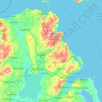
Nombre: Mapa topográfico County Antrim, altitud, relieve.
Lugar: County Antrim, Northern Ireland, United Kingdom (54.47728 -6.66899 55.31309 -5.68796)
Altitud media: 70 m
Altitud mínima: -1 m
Altitud máxima: 549 m
A large portion of Antrim is hilly, especially in the east, where the highest elevations are attained. The range runs north and south, and, following this direction, the highest points are Knocklayd 514 m (1,690 ft), Slieveanorra 508 m (1,670 ft), Trostan 550 m (1,800 ft), Slemish 437 m (1,430 ft), Agnew's Hill 474 m (1,560 ft) and Divis 478 m (1,570 ft). The inland slope is gradual, but on the northern shore the range terminates in abrupt and almost perpendicular declivities, and here, consequently, some of the finest coast scenery in the world is found, widely differing, with its unbroken lines of cliffs, from the indented coast-line of the west. The most remarkable cliffs are those formed of perpendicular basaltic columns, extending for many miles, and most strikingly displayed in Fair Head and the celebrated Giant's Causeway. From the eastern coast the hills rise instantly but less abruptly, and the indentations are wider and deeper. On both coasts there are several resort towns, including Portrush (with well-known golf links), Portballintrae and Ballycastle; on the east Cushendun, Cushendall and Waterfoot on Red Bay, Carnlough and Glenarm, Larne on the Sea of Moyle, and Whitehead on Belfast Lough. All are somewhat exposed to the easterly winds prevalent in spring. The only island of size is the L-shaped Rathlin Island, off Ballycastle, 11 km (6.8 mi) in total length by 2 km (1.2 mi) maximum breadth, 7 km (4.3 mi) from the coast, and of similar basaltic and limestone formation to that of the mainland. It is partially arable, and supports a small population. Islandmagee is a peninsula separating Larne Lough from the North Channel.
Otros mapas topográficos
Haga clic en un mapa para ver su topografía, su altitud y su relieve.
Killyberry Boyd
United Kingdom > Northern Ireland
Killyberry Boyd, Northern Ireland, United Kingdom
Altitud media: 35 m
Hilltown
United Kingdom > Northern Ireland > County Down
Hilltown, County Down, Northern Ireland, BT34 5UH, United Kingdom
Altitud media: 136 m
Newcastle Road
United Kingdom > Northern Ireland
Newcastle Road, Northern Ireland, United Kingdom
Altitud media: 8 m
Newtownards
United Kingdom > Northern Ireland > County Down
Newtownards, County Down, Northern Ireland, BT23 4FA, United Kingdom
Altitud media: 50 m
Whiterock
United Kingdom > Northern Ireland > County Down
Whiterock, County Down, Northern Ireland, BT23 6QH, United Kingdom
Altitud media: 11 m
Binian Lough
United Kingdom > Northern Ireland > County Down
Binian Lough, County Down, Northern Ireland, United Kingdom
Altitud media: 411 m
Clough
United Kingdom > Northern Ireland > County Down
Clough, County Down, Ulster, Northern Ireland, BT30 8RB, United Kingdom
Altitud media: 32 m
Belfast
United Kingdom > Northern Ireland > County Antrim
Belfast, County Antrim, Northern Ireland, United Kingdom
Altitud media: 92 m
Cave Hill
United Kingdom > Northern Ireland > County Antrim > Belfast
Cave Hill, Greencastle, Belfast, County Antrim, Northern Ireland, BT15 5GL, United Kingdom
Altitud media: 172 m
Giant's Causeway
United Kingdom > Northern Ireland > County Antrim
Giant's Causeway, County Antrim, Ulster, Northern Ireland, United Kingdom
Altitud media: 26 m
Whitecross
United Kingdom > Northern Ireland
Whitecross, Newry, Mourne and Down District Council, Northern Ireland, BT60 2UF, United Kingdom
Altitud media: 127 m
West Division
United Kingdom > Northern Ireland
West Division, Northern Ireland, United Kingdom
Altitud media: 128 m
Crossmaglen
United Kingdom > Northern Ireland
Crossmaglen, Newry, Mourne and Down District Council, Northern Ireland, United Kingdom
Altitud media: 123 m
Cappagh
United Kingdom > Northern Ireland
Cappagh, Northern Ireland, United Kingdom
Altitud media: 234 m
Drumragh (Caldwell)
United Kingdom > Northern Ireland > County Tyrone
Drumragh (Caldwell), County Tyrone, Ulster, Northern Ireland, United Kingdom
Altitud media: 87 m
Dungannon
United Kingdom > Northern Ireland > County Tyrone
Dungannon, County Tyrone, Northern Ireland, BT70 1BD, United Kingdom
Altitud media: 76 m
Carryduff
United Kingdom > Northern Ireland > County Down
Carryduff, County Down, Ulster, Northern Ireland, BT8 8DN, United Kingdom
Altitud media: 110 m
Portadown
United Kingdom > Northern Ireland > County Armagh
Portadown, County Armagh, Ulster, Northern Ireland, BT62 1BF, United Kingdom
Altitud media: 28 m
Loughgall
United Kingdom > Northern Ireland > County Armagh
Loughgall, County Armagh, Ulster, Northern Ireland, BT61 8HY, United Kingdom
Altitud media: 32 m
Belcoo
United Kingdom > Northern Ireland > County Fermanagh
Belcoo, County Fermanagh, Ulster, Northern Ireland, BT93 5FB, United Kingdom
Altitud media: 86 m
Ahoghill
United Kingdom > Northern Ireland > County Antrim
Ahoghill, County Antrim, Ulster, Northern Ireland, BT42 1JZ, United Kingdom
Altitud media: 84 m
Moher
United Kingdom > Northern Ireland > County Fermanagh
Moher, Lea, County Fermanagh, Ulster, Northern Ireland, BT92 4FJ, United Kingdom
Altitud media: 65 m
Aughnahoory
United Kingdom > Northern Ireland > County Down > Kilkeel
Aughnahoory, Kilkeel, County Down, Ulster, Northern Ireland, United Kingdom
Altitud media: 60 m
County Armagh
United Kingdom > Northern Ireland
County Armagh, Ulster, Northern Ireland, United Kingdom
Altitud media: 98 m
County Londonderry
United Kingdom > Northern Ireland
County Londonderry, Ulster, Northern Ireland, United Kingdom
Altitud media: 128 m
Mourne Mountains Middle
United Kingdom > Northern Ireland
Mourne Mountains Middle, Ulster, Northern Ireland, United Kingdom
Altitud media: 348 m
Tempo
United Kingdom > Northern Ireland > County Fermanagh
Tempo, County Fermanagh, Ulster, Northern Ireland, BT94 3LU, United Kingdom
Altitud media: 127 m
Ballyfatten
United Kingdom > Northern Ireland
Ballyfatten, Ulster, Northern Ireland, BT82 9PY, United Kingdom
Altitud media: 34 m
Coleraine
United Kingdom > Northern Ireland > County Londonderry
Coleraine, County Londonderry, Ulster, Northern Ireland, BT52 1EP, United Kingdom
Altitud media: 40 m
McLean's Hill
United Kingdom > Northern Ireland > County Down > Bryansford
McLean's Hill, Bryansford, County Down, Ulster, Northern Ireland, BT31 9HH, United Kingdom
Altitud media: 93 m
Carr
United Kingdom > Northern Ireland
Carr, Ulster, Northern Ireland, United Kingdom
Altitud media: 60 m
Horse Island
United Kingdom > Northern Ireland > County Fermanagh
Horse Island, County Fermanagh, Ulster, Northern Ireland, United Kingdom
Altitud media: 46 m
Armagh
United Kingdom > Northern Ireland > County Armagh > Armagh
Armagh, County Armagh, Ulster, Northern Ireland, United Kingdom
Altitud media: 100 m
Newry
United Kingdom > Northern Ireland > County Down > Newry
Newry, County Down, Northern Ireland, BT34 1DG, United Kingdom
Altitud media: 129 m
Limavady
United Kingdom > Northern Ireland > County Londonderry
Limavady, County Londonderry, Ulster, Northern Ireland, BT49 0EP, United Kingdom
Altitud media: 37 m
Upper Ballysillan
United Kingdom > Northern Ireland > County Antrim
Upper Ballysillan, County Antrim, Northern Ireland, United Kingdom
Altitud media: 254 m
Glynn
United Kingdom > Northern Ireland > County Antrim > Glynn
Glynn, County Antrim, Northern Ireland, BT40 3HF, United Kingdom
Altitud media: 63 m
Armagh
United Kingdom > Northern Ireland > Armagh
Armagh, County Armagh, Northern Ireland, BT61 7DJ, United Kingdom
Altitud media: 85 m
Groomsport
United Kingdom > Northern Ireland > County Down > Groomsport
Groomsport, County Down, Northern Ireland, BT19 6JR, United Kingdom
Altitud media: 10 m
Newry
United Kingdom > Northern Ireland > County Down > Newry
Newry, County Down, Northern Ireland, United Kingdom
Altitud media: 73 m
Lough Aghery
United Kingdom > Northern Ireland
Lough Aghery, County Down, Northern Ireland, United Kingdom
Altitud media: 129 m
Larne
United Kingdom > Northern Ireland > County Antrim > Larne
Larne, County Antrim, Northern Ireland, BT40 1HU, United Kingdom
Altitud media: 54 m
Dromore
United Kingdom > Northern Ireland > County Down
Dromore, County Down, Northern Ireland, BT25 1BL, United Kingdom
Altitud media: 106 m
Banbridge
United Kingdom > Northern Ireland > County Down
Banbridge, County Down, Ulster, Northern Ireland, BT32 3AD, United Kingdom
Altitud media: 90 m
Heron Island
United Kingdom > Northern Ireland > County Fermanagh
Heron Island, County Fermanagh, Ulster, Northern Ireland, United Kingdom
Altitud media: 47 m
Belfast
United Kingdom > Northern Ireland > County Antrim
Belfast, County Antrim, Ulster, Northern Ireland, BT1 5GS, United Kingdom
Altitud media: 87 m
Annaclone
United Kingdom > Northern Ireland > Katesbridge
Annaclone, Katesbridge, County Down, Northern Ireland, United Kingdom
Altitud media: 107 m
White Island
United Kingdom > Northern Ireland
White Island, County Fermanagh, Northern Ireland, United Kingdom
Altitud media: 48 m
Lisburn
United Kingdom > Northern Ireland > County Antrim
Lisburn, County Antrim, Northern Ireland, BT28 1BJ, United Kingdom
Altitud media: 92 m
Castlewellan Forest Park
United Kingdom > Northern Ireland > Castlewellan
Castlewellan Forest Park, Clarkill, Castlewellan, County Down, Northern Ireland, United Kingdom
Altitud media: 145 m