
Haz una donación
Mapa topográfico Grand Traverse Bay
Haga clic en el mapa para ver la altitud.
Haz una donación
Acerca de este mapa
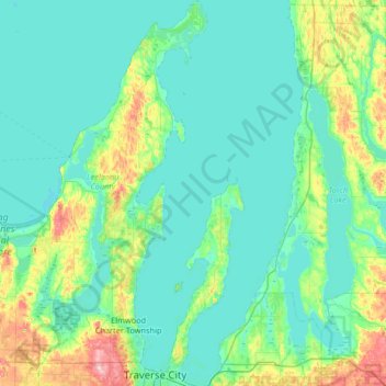
Nombre: Mapa topográfico Grand Traverse Bay, altitud, relieve.
Altitud media: 201 m
Altitud mínima: 171 m
Altitud máxima: 361 m
Haz una donación
Otros mapas topográficos
Haga clic en un mapa para ver su topografía, su altitud y su relieve.
Lookout Point
United States > Michigan > Grand Traverse County > Peninsula Township
Altitud media: 188 m
Old Mission
United States > Michigan > Grand Traverse County
Old Mission is located just east of M-37 near the tip of Old Mission Peninsula about 16 miles (25.75 km) north of Traverse City. The community was built along Old Mission Harbor, which is a small safe haven along the East Arm of Grand Traverse Bay. The community sits at an elevation of 587 feet (179 m) above…
Altitud media: 190 m
Haz una donación
Diamond Park
United States > Michigan > Grand Traverse County > Green Lake Township
Altitud media: 255 m