
Haz una donación
Mapa topográfico Interlochen
Haga clic en el mapa para ver la altitud.
Haz una donación
Acerca de este mapa
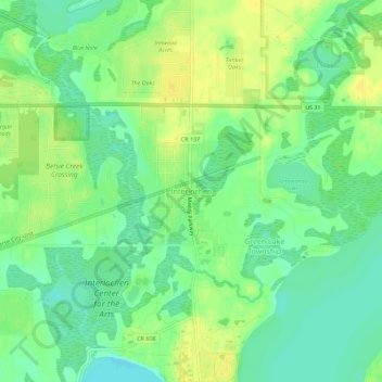
Nombre: Mapa topográfico Interlochen, altitud, relieve.
Altitud media: 258 m
Altitud mínima: 247 m
Altitud máxima: 268 m
Haz una donación
Otros mapas topográficos
Haga clic en un mapa para ver su topografía, su altitud y su relieve.
Traverse City
United States > Michigan > Grand Traverse County
The locale and topography is conducive for road bicycling, aided by the TART trail system. A map with routes, different trips, advice and local knowledge is available. Lake Michigan presents a location for sailing, fishing, and kayaking.
Altitud media: 204 m
Haz una donación
Grand Traverse Commons Natural Area
United States > Michigan > Grand Traverse County > Traverse City
Altitud media: 203 m
Haz una donación
Haz una donación
Traverse City
United States > Michigan > Grand Traverse County
The locale and topography is conducive for road bicycling, aided by the TART trail system. A map with routes, different trips, advice and local knowledge is available. Lake Michigan presents a location for sailing, fishing, and kayaking.
Altitud media: 204 m
Haz una donación