
Mapa topográfico Kamo
Mapa interactivo
Haga clic en el mapa para ver la altitud.
Acerca de este mapa
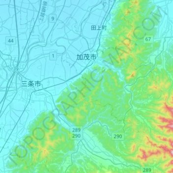
Nombre: Mapa topográfico Kamo, altitud, relieve.
Lugar: Kamo, Niigata Prefecture, Chubu Region, Japan (37.55311 138.98911 37.71061 139.23446)
Altitud media: 76 m
Altitud mínima: 1 m
Altitud máxima: 605 m
Kamo is located in an inland region of north-central Niigata Prefecture. As the city name implies, the Kamo River flows through the city. The highest elevation is the summit of Mount Awagatake at 1292 meters. The city is located roughly halfway between the two larger cities of Nagaoka and Niigata.
Otros mapas topográficos
Haga clic en un mapa para ver su topografía, su altitud y su relieve.
Mount Fuji
Japan > Sunto County > Oyama
Mount Fuji, Oyama, Sunto County, Shizuoka Prefecture, Chubu Region, Japan
Altitud media: 3.261 m
Ibaraki
Ibaraki, Higashiibaraki County, Ibaraki Prefecture, 311-3116, Japan
Altitud media: 26 m
Maborikaigan 4-chome Park
Maborikaigan 4-chome Park, Maboricho 3-chome, Yokosuka, Kanagawa Prefecture, 238-8550, Japan
Altitud media: 22 m
Lake Sanaru
Lake Sanaru, Hamamatsu, Shizuoka Prefecture, Chubu Region, Japan
Altitud media: 16 m
Motoyama
Motoyama, Nagaoka County, Kochi Prefecture, 781-3601, Japan
Altitud media: 679 m
Setouchi
Setouchi, Oshima County, Kagoshima Prefecture, Japan
Altitud media: 26 m
Higashishirakawa
Higashishirakawa, Kamo County, Gifu Prefecture, Chubu Region, 509-1392, Japan
Altitud media: 658 m
Nishikigaoka-chuo Park
Nishikigaoka-chuo Park, Nishikigaoka 2-chome, Aoba Ward, Sendai, Miyagi Prefecture, Japan
Altitud media: 197 m