
Mapa topográfico Okinawa Island
Mapa interactivo
Haga clic en el mapa para ver la altitud.
Acerca de este mapa
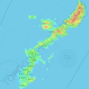
Nombre: Mapa topográfico Okinawa Island, altitud, relieve.
Lugar: Okinawa Island, Okinawa Prefecture, Japan (26.07446 127.62856 26.87552 128.32764)
Altitud media: 14 m
Altitud mínima: 0 m
Altitud máxima: 483 m
The Motobu Peninsula in the north has limestone layers and karst development. In the center and south is mainly a Ryukyu limestone layer and mudstone. The topography is flat, there are few hills over 100 m (328 ft) with very few rivers. The subtropical rains accelerate erosion so there are many drainages and uvala. The southern end of the island consists of uplifted coral reef, whereas the northern half has proportionally more igneous rock. The easily eroded limestone of the south has many caves, the most famous of which is Gyokusendō in Nanjō. The northernmost Cape Hedo is only 22 km (14 mi) away from Yoronjima. Cape Arasaki is the southernmost location of Okinawa island. It is sometimes confused with Cape Kiyanmisaki.
Otros mapas topográficos
Haga clic en un mapa para ver su topografía, su altitud y su relieve.
Ibaraki
Ibaraki, Higashiibaraki County, Ibaraki Prefecture, 311-3116, Japan
Altitud media: 26 m
Maborikaigan 4-chome Park
Maborikaigan 4-chome Park, Maboricho 3-chome, Yokosuka, Kanagawa Prefecture, 238-8550, Japan
Altitud media: 22 m
Mount Fuji
Japan > Sunto County > Oyama
Mount Fuji, Oyama, Sunto County, Shizuoka Prefecture, Chubu Region, Japan
Altitud media: 3.261 m
Lake Sanaru
Lake Sanaru, Hamamatsu, Shizuoka Prefecture, Chubu Region, Japan
Altitud media: 16 m
Motoyama
Motoyama, Nagaoka County, Kochi Prefecture, 781-3601, Japan
Altitud media: 679 m
Setouchi
Setouchi, Oshima County, Kagoshima Prefecture, Japan
Altitud media: 26 m
Higashishirakawa
Higashishirakawa, Kamo County, Gifu Prefecture, Chubu Region, 509-1392, Japan
Altitud media: 658 m
Nishikigaoka-chuo Park
Nishikigaoka-chuo Park, Nishikigaoka 2-chome, Aoba Ward, Sendai, Miyagi Prefecture, Japan
Altitud media: 197 m