
Haz una donación
Mapa topográfico Teaspoon Hill
Haga clic en el mapa para ver la altitud.
Haz una donación
Acerca de este mapa
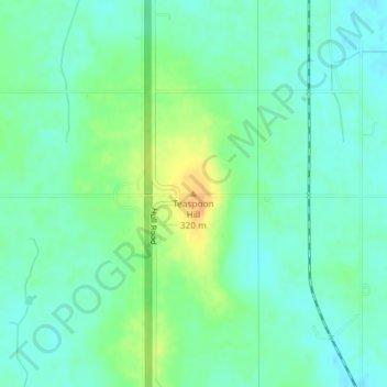
Nombre: Mapa topográfico Teaspoon Hill, altitud, relieve.
Altitud media: 300 m
Altitud mínima: 288 m
Altitud máxima: 323 m
Haz una donación
Otros mapas topográficos
Haga clic en un mapa para ver su topografía, su altitud y su relieve.
Lansing
United States > Michigan > Ingham County
Lansing elevations range between 890 feet (271 m) above sea level on the far south side of Lansing along Northrup Street near the Cedar Street intersection, to 833 feet (254 m) to 805.5 feet (246 m) above sea level along the Grand River.
Altitud media: 263 m
Haz una donación
Haz una donación
Village of Dansville Community Park
United States > Michigan > Ingham County > Dansville
Altitud media: 289 m
Haz una donación
Haz una donación
Haz una donación