
Gracias por apoyar a este sitio ❤️
Haz una donación
Haz una donación
Mapa topográfico Lansing Charter Township
Haga clic en el mapa para ver la altitud.
Gracias por apoyar a este sitio ❤️
Haz una donación
Haz una donación
Acerca de este mapa
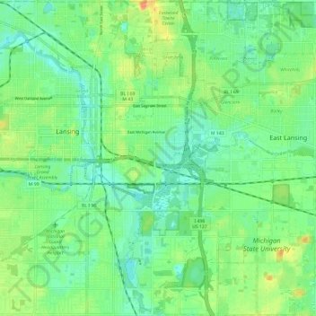
Nombre: Mapa topográfico Lansing Charter Township, altitud, relieve.
Altitud media: 262 m
Altitud mínima: 247 m
Altitud máxima: 289 m
Gracias por apoyar a este sitio ❤️
Haz una donación
Haz una donación
Otros mapas topográficos
Haga clic en un mapa para ver su topografía, su altitud y su relieve.
Village of Dansville Community Park
United States > Michigan > Ingham County > Dansville
Altitud media: 289 m
Gracias por apoyar a este sitio ❤️
Haz una donación
Haz una donación