
Haz una donación
Mapa topográfico Traverse City
Haga clic en el mapa para ver la altitud.
Haz una donación
Traverse City
The locale and topography is conducive for road bicycling, aided by the TART trail system. A map with routes, different trips, advice and local knowledge is available. Lake Michigan presents a location for sailing, fishing, and kayaking.
Haz una donación
Acerca de este mapa
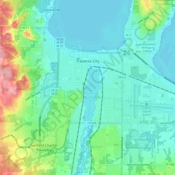
Nombre: Mapa topográfico Traverse City, altitud, relieve.
Altitud media: 204 m
Altitud mínima: 174 m
Altitud máxima: 307 m
Haz una donación
Otros mapas topográficos
Haga clic en un mapa para ver su topografía, su altitud y su relieve.
Lookout Point
United States > Michigan > Grand Traverse County > Peninsula Township
Altitud media: 188 m
Old Mission
United States > Michigan > Grand Traverse County
Old Mission is located just east of M-37 near the tip of Old Mission Peninsula about 16 miles (25.75 km) north of Traverse City. The community was built along Old Mission Harbor, which is a small safe haven along the East Arm of Grand Traverse Bay. The community sits at an elevation of 587 feet (179 m) above…
Altitud media: 190 m
Haz una donación
Diamond Park
United States > Michigan > Grand Traverse County > Green Lake Township
Altitud media: 255 m