
Haz una donación
Mapa topográfico Cleveland National Forest
Haga clic en el mapa para ver la altitud.
Haz una donación
Cleveland National Forest
The Cleveland National Forest encompasses 460,000 acres/720 sq mi (1,900 km2) of inland montane regions—approx. 60 miles from the Pacific Ocean—within the counties of San Diego, Riverside, and Orange, California. The landscape varies somewhat, with mostly chaparral canyons, arroyos and high desert, but dotted with meadows and oak and conifer forests. Near water sources, riparian environments and perennial aquatic plants attract native and migratory wildlife, such as at San Diego’s man-made Lake Cuyamaca. A generally warm and dry, inland-Mediterranean climate prevails over the forest, with the cooler months producing morning frost and snowfall (in the higher elevations). It is the southernmost U.S. National Forest of California. The area is administered by the U.S. Forest Service, a government agency within the United States Department of Agriculture, and is locally overseen by the Descanso, Palomar and Trabuco Ranger Districts.
Haz una donación
Acerca de este mapa
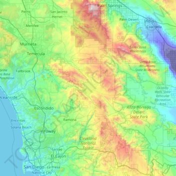
Nombre: Mapa topográfico Cleveland National Forest, altitud, relieve.
Altitud media: 596 m
Altitud mínima: -71 m
Altitud máxima: 3.198 m
Haz una donación
Otros mapas topográficos
Haga clic en un mapa para ver su topografía, su altitud y su relieve.
Ramona
United States > California > San Diego County
In January 2006, Ramona Valley was designated the country's 162nd American Viticultural Area (AVA) by the Alcohol and Tobacco Tax and Trade Bureau, which recognized the area for its distinctive microclimate, elevation, and soil attributes.
Altitud media: 469 m
Haz una donación
Lake Murray Reservoir
United States > California > San Diego County > San Diego > San Carlos
Altitud media: 178 m
Haz una donación
Haz una donación
Rancho Peñasquitos
United States > California > San Diego County > San Diego
The highest point in the community is Black Mountain, which rises to an elevation of 1,500 feet (460 m).
Altitud media: 157 m
Haz una donación
Haz una donación
Haz una donación
Haz una donación
4S Ranch
United States > California > San Diego County
4S Ranch is underlain by Jurassic Santiago Peak Volcanics, Tertiary Stadium conglomerate, and slope wash alluvium. The land of 4S Ranch before development consisted of a variety of landforms ranging from nearly flat-lying mesas and gently rolling hills to rugged, steeply-sloping hillside terrain. Elevations…
Altitud media: 183 m
San Diego
United States > California > San Diego County > San Diego
The climate in San Diego, like most of Southern California, often varies significantly over short geographical distances, resulting in microclimates. In San Diego, this is mostly because of the city's topography (the Bay, and the numerous hills, mountains, and canyons). Frequently, particularly during the "May…
Altitud media: 57 m
Haz una donación
Haz una donación
Torrey Pines State Natural Reserve
United States > California > San Diego County > San Diego
Altitud media: 37 m
Haz una donación
Case Spring
United States > California > San Diego County > Marine Corps Base Camp Pendleton
Altitud media: 687 m
Haz una donación
Haz una donación
Haz una donación
Haz una donación
Haz una donación
Pala
United States > California > San Diego County
The community is in the Pacific time zone. Pala is at an altitude of 404 feet, located at 33°21′55″N 117°04′36″W / 33.36528°N 117.07667°W / 33.36528; -117.07667 (latitude 33.365N, longitude 117.075W).
Altitud media: 189 m
Haz una donación
Flynn Springs County Park
United States > California > San Diego County > El Cajon > Flinn Springs
Altitud media: 330 m
Haz una donación
Haz una donación
Las Flores
United States > California > San Diego County > Marine Corps Base Camp Pendleton
Altitud media: 21 m
Haz una donación
Haz una donación
Camp Pendleton
United States > California > San Diego County > Marine Corps Base Camp Pendleton
Altitud media: 24 m
Haz una donación
Pine Valley
United States > California > San Diego County
Pine Valley is named for the locally unique strand of Jeffrey pine (Pinus jeffreyi) found along Pine Valley Creek, a seasonal drainage in the foothills of the Laguna Mountains in central San Diego County. According to the United States Geological Survey, Pine Valley is located 3,736 feet (1,139 m) above sea…
Altitud media: 1.291 m
Haz una donación
Haz una donación