
Mapa topográfico Laichstätt
Mapa interactivo
Haga clic en el mapa para ver la altitud.
Acerca de este mapa
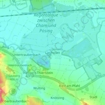
Nombre: Mapa topográfico Laichstätt, altitud, relieve.
Lugar: Laichstätt, Cham, Landkreis Cham, Bayern, 93482, Deutschland (49.19402 12.57717 49.23402 12.61717)
Altitud media: 374 m
Altitud mínima: 354 m
Altitud máxima: 464 m
Otros mapas topográficos
Haga clic en un mapa para ver su topografía, su altitud y su relieve.
Selling
Deutschland > Bayern > Landkreis Cham > Cham > Kothmaißling
Selling, Kothmaißling, Cham, Landkreis Cham, Bayern, 93486, Deutschland
Altitud media: 399 m
Haidhäuser
Deutschland > Bayern > Landkreis Cham > Cham
Haidhäuser, Cham, Landkreis Cham, Bayern, Deutschland
Altitud media: 381 m
Chammünster
Deutschland > Bayern > Landkreis Cham > Cham
Chammünster, Cham, Landkreis Cham, Bayern, 93413, Deutschland
Altitud media: 399 m
Gutmaning
Deutschland > Bayern > Landkreis Cham > Cham
Gutmaning, Cham, Landkreis Cham, Bayern, 93413, Deutschland
Altitud media: 412 m