
Mapa topográfico Solukhumbu
Mapa interactivo
Haga clic en el mapa para ver la altitud.
Acerca de este mapa
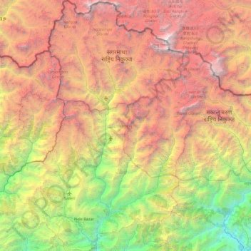
Nombre: Mapa topográfico Solukhumbu, altitud, relieve.
Lugar: Solukhumbu, Province #1, Nepal (27.33820 86.35572 28.11375 87.00996)
Altitud media: 3.997 m
Altitud mínima: 299 m
Altitud máxima: 8.716 m
Solukhumbu is a Himalayan district of Province No. 1 of Nepal, situated on the north-west corner of province. It is one out of 3 Himalayan districts of Province No. 1. Total area of district is 3,312 square kilometres (1,279 sq mi). It is situated between Lat. 27°20'39" to 28°6'24" North and Long. 86°0'21" to 87°0'1" East. The highest elevation of district is 8,848 metres (29,029 ft) (Mount Everest) and the lowest elevation is 600 metres (2,000 ft) (Tuintar) above sea level. The district is surrounded by Sankhuwasabha in east, Bhojpur in south-east, Khotang and Okhaldhunga in south, Bagmati Pradesh in west and Tibet (China) in north.
Otros mapas topográficos
Haga clic en un mapa para ver su topografía, su altitud y su relieve.
Mount Everest
Nepal > Koshi Province > Solukhumbu
Mount Everest, Khumbupasanglahmu, Solukhumbu, Koshi Province, Nepal
Altitud media: 7.847 m
Kachankawal
Nepal > Koshi Province > Jhapa
Kachankawal, Jhapa, Koshi Province, Nepal
Altitud media: 72 m
Chandrakot
Nepal > Lumbini Province > Gulmi
Chandrakot, Gulmi, Lumbini Province, Nepal
Altitud media: 1.592 m
Sarketari Baandh/ Risk And Hazards/ Flood
Nepal > Dhading > Dhading Besi
Sarketari Baandh/ Risk And Hazards/ Flood, Nilkantha Municipality Ward No. 4, Dhading Besi, Nilakantha, Dhading, Bagmati Pradesh, Nepal
Altitud media: 933 m
Mount Everest
Nepal > Koshi Province > Solukhumbu
Mount Everest, Khumbupasanglahmu, Solukhumbu, Koshi Province, Nepal
Altitud media: 7.850 m
Mount Everest
Nepal > Eastern Development Region > Khumjung
Mount Everest, Khumjung, Khumbupasanglahmu, Solukhumbu, Province #1, Nepal
Altitud media: 7.841 m
Kathmandu
Nepal > Central Development Region > Kathmandu
Kathmandu, Bagmati, Central Development Region, Nepal
Altitud media: 1.331 m
Chilime Khola
Chilime Khola, Briddhim, Gosaikunda, Rasuwa, Bagmati Pradesh, Nepal
Altitud media: 1.871 m
Jomsom
Nepal > Western Development Region > Jomsom
Jomsom, Mustang, Dhaulagiri, Western Development Region, Nepal
Altitud media: 3.031 m
Ghandruk
Nepal > Western Development Region > Ghandruk
Ghandruk, Kaski, Gandaki, Western Development Region, Nepal
Altitud media: 3.527 m
Devadaha
Nepal > Western Development Region > Devadaha
Devadaha, Rupandehi, Lumbini, Western Development Region, Nepal
Altitud media: 295 m
Dharapani
Nepal > Western Development Region > Dharapani
Dharapani, Arghakhanchi, Lumbini, Western Development Region, Nepal
Altitud media: 1.195 m
Himalayas
Nepal > Solukhumbu > Khumjung
Himalayas, Khumjung, Khumbupasanglahmu, Solukhumbu, Province #1, Nepal
Altitud media: 7.555 m
Lhotse Shar
Nepal > Eastern Development Region > Khumjung
Lhotse Shar, Khumjung, Solukhumbu, Sagarmatha, Eastern Development Region, Nepal
Altitud media: 7.153 m
Darling
Nepal > Western Development Region > Darling
Darling, Gulmi, Lumbini, Western Development Region, Nepal
Altitud media: 1.681 m
Mahakali
Nepal > Far-Western Development Region
Mahakali, Far-Western Development Region, Nepal
Altitud media: 1.733 m
Annapurna II
Nepal > Western Development Region > Parche
Annapurna II, Parche, Kaski, Gandaki, Western Development Region, Nepal
Altitud media: 7.052 m
Mechi
Nepal > Eastern Development Region
Mechi, Eastern Development Region, Nepal
Altitud media: 1.902 m
Annapurna I
Nepal > Western Development Region > Ghandruk
Annapurna I, Ghandruk, Kaski, Gandaki, Western Development Region, Nepal
Altitud media: 7.127 m
Koshi
Nepal > Eastern Development Region
Koshi, Eastern Development Region, Nepal
Altitud media: 1.899 m
Tara
Nepal > Western Development Region > Tara
Tara, Baglung, Dhaulagiri, Western Development Region, Nepal
Altitud media: 2.315 m
Mahalangur Himal
Nepal > Eastern Development Region > Makalu
Mahalangur Himal, Makalu, Sankhuwasabha, Koshi, Eastern Development Region, Nepal
Altitud media: 4.695 m
Dhaulagiri
Nepal > Western Development Region > Mudi
Dhaulagiri, Mudi, Myagdi, Dhaulagiri, Western Development Region, Nepal
Altitud media: 7.321 m
Gandaki
Nepal > Western Development Region
Gandaki, Western Development Region, Nepal
Altitud media: 2.842 m
Island Peak
Nepal > Eastern Development Region > Khumjung
Island Peak, Khumjung, Solukhumbu, Sagarmatha, Eastern Development Region, Nepal
Altitud media: 5.461 m
Khumbu Glacier
Nepal > Eastern Development Region > Khumjung > Khumjung
Khumbu Glacier, Khumjung, Solukhumbu, Sagarmatha, Eastern Development Region, Nepal
Altitud media: 6.297 m
Ghaghara River
Nepal > Mid-Western Development Region
Ghaghara River, Dailekh, Bheri, Mid-Western Development Region, 271833, Nepal
Altitud media: 1.522 m
Bagmati
Nepal > Central Development Region
Bagmati, Central Development Region, Nepal
Altitud media: 2.279 m
Chilime Khola
Nepal > Central Development Region
Chilime Khola, Rasuwa, Bagmati, Central Development Region, Nepal
Altitud media: 2.388 m