
Mapa topográfico Mizoram
Mapa interactivo
Haga clic en el mapa para ver la altitud.
Acerca de este mapa
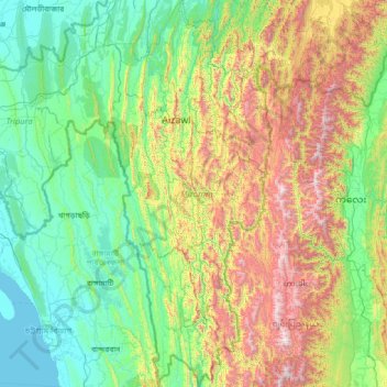
Nombre: Mapa topográfico Mizoram, altitud, relieve.
Lugar: Mizoram, India (21.94126 92.26022 24.52120 93.43737)
Altitud media: 544 m
Altitud mínima: 0 m
Altitud máxima: 2.637 m
Mizoram is a land of rolling hills, valleys, rivers and lakes. As many as 21 major hill ranges or peaks of different heights run through the length and breadth of the state, with plains scattered here and there. The average height of the hills to the west of the state is about 1,000 metres (3,300 ft). These gradually rise up to 1,300 metres (4,300 ft) to the east. Some areas, however, have higher ranges which go up to a height of over 2,000 metres (6,600 ft). Phawngpui Tlang also known as the Blue Mountain, situated in the southeastern part of the state, is the highest peak in Mizoram at 2,210 metres (7,250 ft). About 76% of the state is covered by forests, 8% is fallows land, 3% is barren and considered uncultivable area, while cultivable and sown area constitutes the rest. Slash-and-burn or jhum cultivation, though discouraged, remains in practice in Mizoram and affects its topography. A report by Ministry of Environment, Forest and Climate Change in 2021 states that Mizoram has the highest forest cover as a percentage of its geographical area of any Indian state, being 84.53% forest.
Otros mapas topográficos
Haga clic en un mapa para ver su topografía, su altitud y su relieve.
Puducherry
India > Puducherry > Puducherry Taluk
Puducherry, Puducherry Taluk, Puducherry District, Puducherry, 605001, India
Altitud media: 10 m
KOLLI HILLS
KOLLI HILLS, Namakkal District, Tamil Nadu, 637411, India
Altitud media: 563 m
Tarapith
India > West Bengal > Rampurhat - II
Tarapith, Rampurhat - II, Birbhum District, West Bengal, 731233, India
Altitud media: 32 m
Bagalkote
India > Karnataka > Bagalakote taluk
Bagalkote, Bagalakote taluk, Bagalkote District, Karnataka, 587102, India
Altitud media: 556 m
Phooliya Kalan Tehsil
Phooliya Kalan Tehsil, Bhilwara District, Rajasthan, India
Altitud media: 374 m
Sliding Rock
India > Andhra Pradesh > Kurabalakota > Mandemvaripalli > Sriramavaripalli
Sliding Rock, Sriramavaripalli, Mandemvaripalli, Kurabalakota, Annamayya District, Andhra Pradesh, 517352, India
Altitud media: 740 m
Moreh
India > Manipur > Tengnoupal tehsil
Moreh, Tengnoupal tehsil, Tengnoupal District, Manipur, 795131, India
Altitud media: 270 m
Kallakurichi
India > Tamil Nadu > Kallakkurichi
Kallakurichi, Kallakkurichi, Kallakurichi District, Tamil Nadu, 606200, India
Altitud media: 124 m
Palanpur
India > Gujarat > Palanpur Taluka
Palanpur, Palanpur Taluka, Banas Kantha District, Gujarat, 385001, India
Altitud media: 218 m
Badami
India > Karnataka > Badami taluku
Badami, Badami taluku, Bagalkote district, Karnataka, 587200, India
Altitud media: 587 m
Brindawan
India > Rajasthan > Beejoliya Tehsil
Brindawan, Beejoliya Tehsil, Bhilwara, Rajasthan, India
Altitud media: 489 m
Malviya Nagar
India > Delhi > Hauz Khas Tehsil
Malviya Nagar, Hauz Khas Tehsil, South Delhi, Delhi, India
Altitud media: 229 m
Gudibande
India > Karnataka > Gudibande taluk
Gudibande, Gudibande taluk, Chikkaballapura district, Karnataka, 561209, India
Altitud media: 833 m
Gudibanda
Gudibanda, Sri Sathya Sai, Andhra Pradesh, 515271, India
Altitud media: 682 m
Banganga River
India > Maharashtra > Niphad > Ojhar
Banganga River, Ojhar, Niphad, Nashik, Maharashtra, 422206, India
Altitud media: 584 m
Bengaluru
India > Karnataka > Bangalore North > Bengaluru
Bengaluru, Bangalore North, Bangalore Urban, Karnataka, 560001, India
Altitud media: 879 m
Bharmour
India > Himachal Pradesh > Brahmaur > Bharmour
Bharmour, Brahmaur, Chamba, Himachal Pradesh, 176315, India
Altitud media: 2.204 m
Laxmidevipally mandal
India > Telangana > Laxmidevipally mandal
Laxmidevipally mandal, Bhadradri Kothagudem, Telangana, 507101, India
Altitud media: 148 m
Ram Nagar
India > Uttar Pradesh > Sambhal > Ram Nagar
Ram Nagar, Sambhal, Uttar Pradesh, India
Altitud media: 204 m
Beerwah
India > Jammu and Kashmir > Beerwah
Beerwah, Budgam District, Jammu and Kashmir, India
Altitud media: 1.785 m
Bandipur National Park/Tiger Reserve
India > Karnataka > Gundlupet taluk
Bandipur National Park/Tiger Reserve, Gundlupet taluk, Chamarajanagar District, Karnataka, India
Altitud media: 860 m
Chini
India > Chhattisgarh > Tamnar Tahsil
Chini, Tamnar Tahsil, Raigarh, Chhattisgarh, India
Altitud media: 337 m
Ganges
India > Uttar Pradesh > Ghazipur
Ganges, Ghazipur, Uttar Pradesh, 233001, India
Altitud media: 1.626 m
Shamirpet mandal
Shamirpet mandal, Medchal–Malkajgiri, Telangana, 500078, India
Altitud media: 574 m
Car Nicobar
India > Andaman and Nicobar Islands
Car Nicobar, Nicobar, Andaman and Nicobar Islands, India
Altitud media: 11 m
Dharavi
India > Maharashtra > Mumbai
Dharavi, Zone 2, Mumbai, Mumbai City, Maharashtra, India
Altitud media: 6 m
Kalimpong
India > West Bengal > Kalimpong
Kalimpong, Kalimpong -I, Kalimpong, West Bengal, 734301, India
Altitud media: 838 m
Secunderabad
India > Telangana > Secunderabad
Secunderabad, Maredpally mandal, Hyderabad, Telangana, 500003, India
Altitud media: 544 m
Jammu
India > Jammu and Kashmir > Jammu
Jammu, Jammu District, Jammu and Kashmir, 180001, India
Altitud media: 367 m