
Haz una donación
Mapa topográfico Wicomico County
Haga clic en el mapa para ver la altitud.
Haz una donación
Wicomico County
The county's boundary with Delaware is composed of the Mason-Dixon line and the Transpeninsular Line. The intersection of these two historical lines is the midpoint of the Transpeninsular Line, fixed by Mason and Dixon between 1763 and 1767. The midpoint is located about 8 miles (13 km) northwest of Salisbury, near the center of the Delmarva Peninsula. The county is generally flat, characteristic of the region, with a few small hills in the northeast. The lowest elevation is at sea level and the highest elevation is 98 ft (30 m).
Haz una donación
Acerca de este mapa
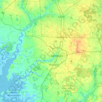
Nombre: Mapa topográfico Wicomico County, altitud, relieve.
Lugar: Wicomico County, Maryland, United States (38.21580 -75.94373 38.56066 -75.30669)
Altitud media: 9 m
Altitud mínima: -4 m
Altitud máxima: 30 m
Haz una donación
Otros mapas topográficos
Haga clic en un mapa para ver su topografía, su altitud y su relieve.
Baltimore
United States > Maryland > Baltimore
Baltimore is in north-central Maryland on the Patapsco River close to where it empties into the Chesapeake Bay. The city is also located on the fall line between the Piedmont Plateau and the Atlantic coastal plain, which divides Baltimore into "lower city" and "upper city". The city's elevation ranges from sea…
Altitud media: 65 m
Haz una donación
Haz una donación
Haz una donación
Highland
United States > Maryland > Frederick County
The majority of the downtown Highland district is situated within the 418-acre (169 ha) land grant named "Hickory Ridge". The Rouse Company borrowed the land grant name for one of its nearby villages of Columbia, built in 1974. The historic "White Hall" or "Hickory Ridge" estate (1749) was owned by the…
Altitud media: 357 m
Haz una donación
Haz una donación
Haz una donación
Hoye-Crest
United States > Maryland > Garrett County
Hoye-Crest is a summit along Backbone Mountain just inside of Garrett County, Maryland. It is the highest natural point in Maryland at an elevation of 3,360 feet (1,020 m).
Altitud media: 887 m
Haz una donación
Quiet Waters Park
United States > Maryland > Anne Arundel County > Annapolis > Georgetown East
Altitud media: 7 m
Haz una donación
Haz una donación
Haz una donación
Haz una donación
Haz una donación
Antietam National Battlefield
United States > Maryland > Washington County > Sharpsburg
Altitud media: 147 m
Haz una donación
Haz una donación
Haz una donación
Damascus
United States > Maryland > Montgomery County
As an unincorporated area, Damascus' boundaries are not officially defined. Damascus is recognized by the United States Census Bureau as a census-designated place, and by the United States Geological Survey as a populated place located at 39°16′16″N 77°12′22″W / 39.27111°N 77.20611°W /…
Altitud media: 204 m
Haz una donación
Haz una donación
Haz una donación
Haz una donación
Haz una donación
Haz una donación
Haz una donación
Haz una donación
Haz una donación
Haz una donación